You may have never heard of the Aral Sea, even though it was the fourth largest lake in the world as recently as the 1960’s.
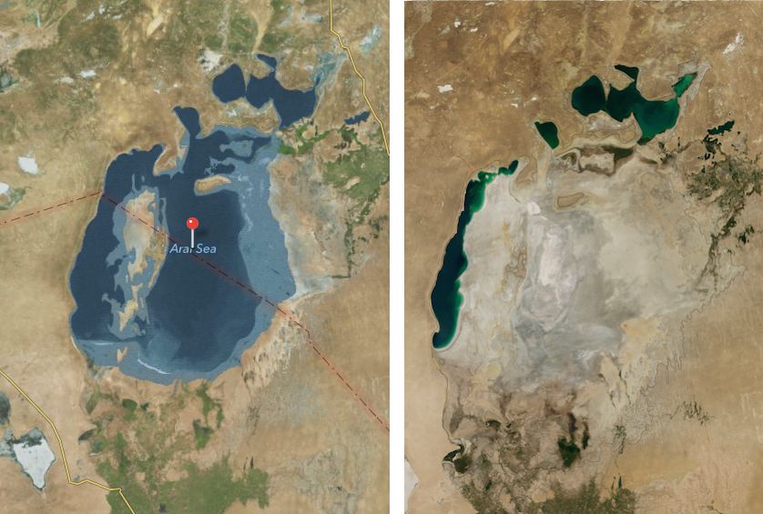
The once-gigantic body of water which rests on the border of Uzbekistan has shrunk to less than 10% of its former size over the last half century. It’s been dubbed one of the worst environmental disasters ever, but looking at Apple Maps you’d never even know the Russians drained the mighty lake dry, destroyed its robust fishing industry, and left behind a wasteland of salt, pollution, and toxic dust storms.
The most recent satellite images from NASA in August 2014 revealed that for the first time in modern history the eastern basin of the Aral Sea has completely dried up. Apple’s images meanwhile show a lush lake that looks like the perfect place to go jet skiing if you’re vacationing in the Kazakstan-Uzbekistan neighborhood.
Water levels of the Aral Sea began to decline dramatically in the 1960’s after the Soviets diverted the two rivers that feed it in an effort to irrigate the desert to grow rice, melons, and cotton. Irrigation projects successfully transformed Uzbekistan into the world’s top cotton exporter by 1988, but it came at a heavy cost.
The receding sea left huge plains covered with salt and toxic chemicals from weapon testing and pesticides and fertilizer runoff. The dust is carried away by the wind as far as Japan and people living around in the area suffer from higher rates of cancer and lung diseases.
Apple Maps doesn’t exactly have a reputation for being the best source of mapping data in the world, so this embarrassing gaffe isn’t much of a surprise. However, it does make us curious where Apple’s getting its out dated satellite images.


7 responses to “Apple Maps error covers up sad truth about disappearing Aral Sea”
Apple more than likely gets their data where they get everything else… Some company in China…
Apple more than likely gets their data where every company gets everything … Some company in China…
Fixed it for you.
There’s probably a boundary defined in some map somewhere and the blue is then defined by the relative elevation to that boundary. Since the lake bed is still at the same elevation…Bob’s your Uncle.
Google seems to have the same problem with accuracy also. They show in between Apple and Nasa. Wonder why that was not mentioned in the article
Google Maps is much more accurate than Apple’s.
Not really. Look at the map view, not the satellite view in google maps.
Look closer. just because it’s colored blue doesn’t mean it’s not desert underneath.