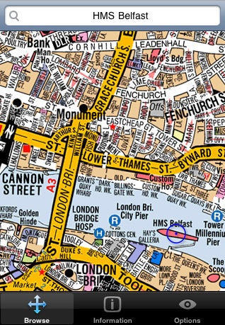
This is more like it. Visual IT has done a deal with the Geographers A-Z Map Company to produce a licensed copy of the Mini London A-Z for iPhone.
Yes, iPhones come with the Google Maps app, but this is a very different thing, for two reasons.
The first is that the maps and associated data are stored on the phone (the App Store says you’ll need about 50MB to store it all, not very much), so there’s no waiting for stuff to download.
The second reason is much more important, and it’s this: the A-Z occupies a special place in the hearts of Londoners. Like the offical Tube map, the A-Z is more than just a map. It’s a symbol of London’s Londonness.
The original A-Z was created by Phyllis Pearsall in the 1930s. She walked 3,000 miles, painstakingly recording and indexing as she went. The map she created has become an indispensable guide to the city for visitors and residents alike. For 10 bucks (six quid) it looks like a bargain, although as I write this there are no reviews on the App Store. Let’s hope, for Phyllis’ sake, that it lives up to its printed namesake.


14 responses to “Mapping App Puts London In Your Pocket”
I think its only real benefit is even if you’re out of a network service area the maps still load, which I guess is a big advantage if you’re on the tube! Otherwise, it really doesn’t do much that Googlemaps already does, and I actually prefer the simplicity of Googlemaps.
The local caching of data is especially useful for iPod touch owners, since you can’t rely on having a data connection. (I suppose that’s also true for iPhone users on the tube).
However, I must disagree on the price: £6 would buy you a paper A-Z, and while, yes, it’s a lot of paper to carry around, it seems that the digital version could be at least a little cheaper.
This is also great for tourist. I might consider getting this for when I go to London. I don’t feel like paying the outrageous data-roaming charges to use Google Maps – much cheaper to have an offline map.
Question is – does it work with the iPhone’s GPS?
Looks good and if I could get my hands on an iPhone here in Spain where I live I am sure I would get an iPhone A to Z of London, having used the paper versions in other English cities. Will there be other cities covered eventually, like Birmingham for example. I am going there in November.
I had this on Windows Mobile and it was moderately useful. What made it less than useful was that it was slow to load, and also the map was split into 9 “tiles” which didn’t automatically scroll to the adjoining tile, you had to load it manually.
If it is one big map that you can scroll around easily and zoom in and out, it might be worth paying for again!
Almost a good reason to invest in a touch – though not the iPhone (£$€!). I think the paper A-Z is likely a bit more useful, unless you don’t normally carry a rucksack/messenger bag. That will mean you have to go with the smallest (A3/4×6″) book, which is a often too big for the pocket, and a little too small to read (especially if you’re over 40). The iPhone App will let you zoom to actually read street names. If it has a directions/routing feature, then it really will be a great app.
A great free alternative is The Tube website (Transport for London/tfl.gov.uk). You get specific directions, including bus+Tube+walking combinations and alternatives, plus you can link to maps. It gives you journey time, departure times, and shows you area bus and tube stops, so you don’t have to walk all the way back if you wander the area. It’s not perfect with place names, so use streets if possible (The Strand vs. Australia House). It even routes you to surrounding towns on the local rail. In an earlier iteration I think it gave you fares, but it doesn’t seem to now.
But being reasonably familiar with the city, and an aging A-Z fan, I think this app combined with a smaller A-Z (maybe not the mini) is worth the extra £6 to get around town. Especially if I’m going anywhere near Barbican. I hate trying to find my way around there at street level.
We also just a shipped a “London-in-your-pocket” iPhone app, called London Envi. Its focus is also on getting around using the Tube, but in particular getting to the top 50 attractions in the City. Details are at http://we-envision.com/londone…