A lot has been written over the last day or so about the crappy maps in iOS 6, and the fact that Apple’s new data engine doesn’t live up to its pretty new map tiles and spectacular flyover feature.
I thought exactly the same thing when I first installed a beta of iOS 6 on my iPad a month or two back. But while Apple’s maps are definitely a step back in many ways, it’s not all as bad as it seems. Not quite anyway.
But guess what? If you’re willing to use a couple extra apps until Apple fixes things, you can get everything back that you’re missing.
Street View
This is the big one, in that it has completely disappeared from the maps app. Street View is one of the neatest features out there. I use it to check out a new location before visiting, to find the nearest bike parking at my destination, or to “drive” through a tricky junction to see if it’ll be a safe route on a bike tour.
Apple’s answer is that you can use its 3-D building view, but while that gives a cold overview of the terrain, it doesn’t let you peek at a storefront and check the sign with the opening hours scrawled on it.
What about the web? Sadly, Street View in the browser requires Flash (remember that?) so you’re out of luck.

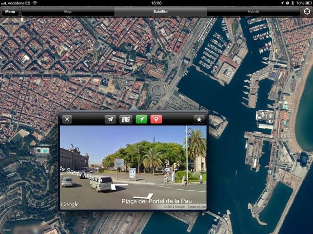
The solution: Live Street View. This is an app which has been around for a while, and brings native Strret View back to iOS 6. Tap on the map (it uses Apple’s new tiles for satellite regular and hybrid views) and a small window pops up with Google’s pictures in it. Better yet, it is compass aware, so you can swing your iPhone or iPad around and the view pans accordingly.
The app lets you save places, search and so on, bringing much of the functionality of a full-on map app. An it costs just $1. If that’s too rich for you, you damn cheapskate, there’s an ad-supported free version.
Transit Directions
The other whine I hear is about transit directions, and directions in general. These are probably coming from bloggers based in San Francisco or on the East Coast, as everybody else in the U.S lives in their cars, right?
Anyhow, over in Europe, the directions seem just fine. Perhaps TomTom — which provides the map data — has better European coverage. But unlike directions (which now give turn-by-turn instructions) transit info has been left out of the Maps app altogether. And I argue that this isn’t such a bad thing.
Google’s transit data is spotty. If you live in an area that’s covered, then great. If not, tough. Apple’s solution is to let local data providers tie their apps into Maps. Steven Wang, developer of vTransit, told me that there are maps APIs which let developers integrate with the Maps app.
So, when you tap the transit button in Maps, a list opens up showing you the apps which can handle it. Wang’s vTransit uses Google transit data, so it should — in theory — show you the same routes as you got before. But the opportunity is there for a whole new category of navigation apps.
For instance, you could choose to open a walking or bike-tour map of a city instead of the bus timetable. Or you could pick a city’s own app. It doesn’t beat the convenience of just having the info right there in Maps when you’re in a foreign city, but then again, many foreign cities you visit will have crappy Google transit directions.
Verdict: Wait for the apps to arrive.
The Web
Can you really not live without Google Maps on your iDevice? Then quit moaning and open up Safari. The mobile version of Google’s maps beats Apple’s in many ways. You get Google’s own directions. You get terrain view. You even get a proper search. And better yet, when you tap on a map in a regular Google search, you are taken to Google Maps in the browser, not booted out to the app.
There’s more: You can access all your saved Google Maps places and bookmarks, and clicking on a location in the search results will take you to reviews, phone number and everything else you need. Save the bookmark on your home screen and enjoy it.
Terrain
You may never have used the terrain view in the old maps app. But if you have an outdoorsy friend, or a cyclist buddy, then they will tell you that they use it as much as any other view. Terrain shows a shaded, contoured view of the world, letting you see at a glance where the hills and mountains lie, and whether that road really does follow the river down at water level.
For getting a good view of the land, terrain view is essential. And now it, like Street View, has gone.
Fortunately, Apple’s implementation is actually better. Even outside of cities that have a 3-D view, you can swipe with two fingers and enter 3-D mode, which is essentially an interactive, 3-D terrain view. This drapes the (flat) satellite imagery over a topographical model.

Thus, you can see where all the bumps and troughs are in any landscape. And because you can use a pair of fingers to zoom and twist the scene, and to view it from any angle, it is actually way, way better than staring at a shaded map with contour lines.
Result: A big win for Apple. And tired cyclists everywhere.
Improvements
So far, we’ve mostly covered the shortcomings of Apple’s v1.0 version of maps. But there must be something good in there, right?
Oh, yes. Yes, there is. If you want to impress somebody, take out your retina iPad, switch to satellite or hybrid view and then enter the 3-D buildings mode. On the hi-res screen, it is nothing short of spectacular, and amazingly even works well on a 3G connection.

You can look at buildings from any angle. You can get close enough to make out objects on balconies, and you can spend hours just touring a foreign city. One virtual trip to Rome is worth the cost of upgrading to iOS 6. What’s that? iOS 6 is free? Wow, that’s an even better deal.
The Future
As I mentioned, this is a 1.0 version of maps, and considering this it’s remarkably good. The problem is that it’s sitting on top of v6.0 of iOS, which is arguably the best OS out there. Add to this the fact that maps are one of mobile computing’s killer apps, and you can see the problem.

Like the floppy drive, and lately the 30-pin dock connector, Apple has favored the yank-the-band-aid-off-in-one-go approach. And Apple is up against the big daddy of mapping here: Google. Which means that — unlike the iPod app or the mail app, which have no real competition — Apple will be putting a lot of work into making maps better. Meanwhile, there are plenty of options to replace the currently missing features.
Don’t believe me? Then maybe you’ve forgotten how shitty the first few iPhone cameras were.
![How To Fix iOS 6 Maps [Feature] My, though, aren't these new maps purty?](https://www.cultofmac.com/wp-content/uploads/2012/09/ios6-maps-05.jpg)

